Drimoleague Heritage Walkways
Drimoleague, which was once the busiest railway junction in West Cork with no fewer than three platforms, has now become the hub of walking networks in the area. Hence the title The Walker’s Junction of West Cork.
Here the well-acclaimed Sheep’s Head Way converges with the six Drimoleague Heritage Walkways, and then continues northwards to Kealkill. St Finbarr’s Pilgrim Way, a 37km ancient pilgrim path to St Finbarr’s hermitage at Gougane Barra, also starts here. The Dunmanway network of walks are accessible from Drimoleague and, with a few green road stretches, you can find your way to the walks at Carrigfadda, near Rosscarbery. Skibbereen is just 13km away, with Lough Hyne, Baltimore and other coastal walks within driving distance.
All the walks featured, along with a pull-out map, interesting historical facts, and nature studies are covered in greater detail in the booklet ‘A Guide to The Sheep’s Head Way – Eastern Routes which is available locally at a reasonable price. For mail order, please e-mail davidross316@gmail.com . Maps courtesy of Dennison Design and Abigail Ross.
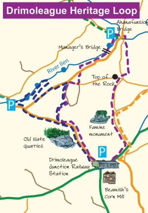
Drimoleague Heritage Loop
Starting point: The Railway Yard, Drimoleague
Duration: 2 hours
Distance: 3.5km
Difficulty: Easy but the pathway is steep in a few places.
Direction: Anti-clockwise
An energetic loop walk combining village landscape, hilltop panorama, woodland and riverbank. This walk has a number of Memorial Benches. Take a while to sit, enjoy the peace and reflect on the people of the area whose lives are commemorated. As you walk along the river, note the heronry in the trees, and watch out for dippers and kingfishers. See map for directions.
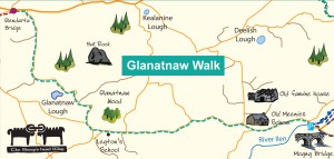
Glanatnaw Walk
Starting point: Moyny Bridge, ending at Glandarta Bridge
Duration: 1 hour 30 mins
Distance: 6.9km
Direction: Linear
A long countryside walk in a beautiful natural environment which features points of historical interest. This walk starts at Moyny Bridge and bears to the left in the direction of Bantry. Along the roadside, the combination of stonewalls and sheltered woodland makes for a great diversity of flowers and foliage from spring to autumn. See map for directions.
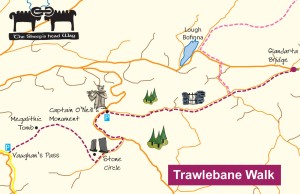
Trawlebane Walk
Starting point: Glandarta Bridge, finishing at Vaughan’s Pass
Duration: 2 hours 30 mins
Distance: 7km
Difficulty: Easy on roads, footing can be soft on hill.
Direction: Westwards
Gentle countryside and hill walk with beautiful views and cultural, archaeological and historical points of interest. The riverbank and the little neck of land created by the changed course of the river are a glorious sight in spring when bluebells carpet the ground. See map for directions. Notice the plaque at Trawlebane Bridge, which commemorates the 150 th anniversary of the birth of Captain Francis O’Neill. Originally from Trawlebane, Francis O’Neill went on to become a Captain in the Chicago Police and was an accomplished fiddler. In 1903 he published ‘O’Neill’s Music of Ireland’ which is still considered to be the most authoritative collection of traditional Irish melodies in a single volume.
Schronacarton Walk
Starting point: The Railway Yard, Drimoleague
Duration: 1 hour 30 mins (there and back)
Distance: 1.5km Difficulty: Easy
Direction: Eastwards, linear
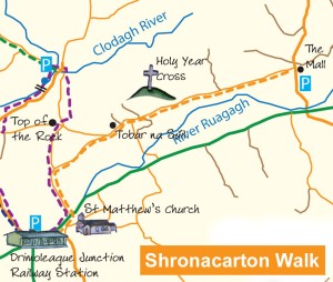
This pleasant stroll starts at the Railway Yard and takes you through Drimoleague’s history leading to a restful amenity area at the mall. Along the route you will see the Holy Year Cross (1950) on the Cnocanín, the highest point of the village. Near this cross is a curious phenomenon of which there are very few in the country. It is a ring fort, but rectangular in shape. Word has it that soldiers camped here in connection with events at Castledonovan. See map for directions.
Deelish Cascades Walk
Starting point: Castledonovan Bridge car park
Duration: 2 hours (there and back)
Distance: 3km
Difficulty: Easy, well surfaced, but beware of flash floods
Direction: Linear, southwards and back
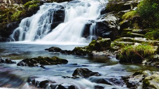
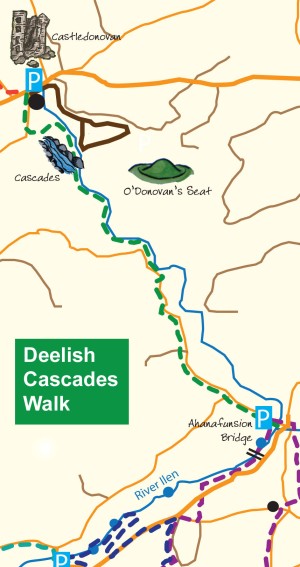
Leaving Castledonovan Bridge, walk the old path along the banks of the Ilen River, with its cascades, cliffs and patchwork field systems. A beautiful riverside walk following the course of the Ilen river until it emerges at Gurteeniher North to follow a quiet country road to Ahanafunsion bridge. The old village of Gurteeniher ran westwards from the present road. It was depopulated at the time of the famine. Today it is once again a busy place with Glenilen Farm producing award winning dairy mousse, yoghurt, cream and old-fashioned country butter. This artisan dairy business is a good example of local sustainable business in a rural area. See map for directions.
Glanaclohy Walk
Starting point: Castledonovan Bridge car park
Duration: Approx 3 hours (there and back)
Distance: 9.5km
Difficulty: Challenging, but a sound surface
Direction: Clockwise
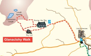
An invigorating loop walk featuring magnificent hilltop views over Bantry Bay. This walk takes you up an old bog road, beside rushing streams, two lakes and the huge erratic rocks after which Glanaclohy is named. You can visit the old homestead of George the Sky, so called because his house was situated so near the sky, and wonder what it was like for him and his family in days gone by. See map for directions.
Mealagh Valley Walk
Starting point: Near Coomanore Lough
Duration:3 hours 30 mins
Distance: 12km
Difficulty: Challenging, on hills, footing can be soft. Easier on the roadways.
Direction: Northwards
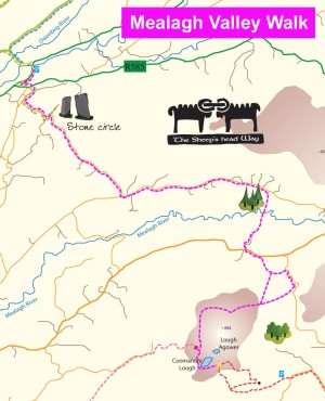
Starting near Coomanore Lough, the Mullaghmesha to Kealkill walk offers breathtaking views, history and heritage. Along the way, look out for an ancient crab apple tree growing atop a large rock. There is a fine heathland on these old red sandstone hills with the pink and purple flowers of bell heather and ling. You may be lucky enough to see or hear the relatively rare red grouse with its harsh call of ‘go-back go-back go-back’. See map for directions.
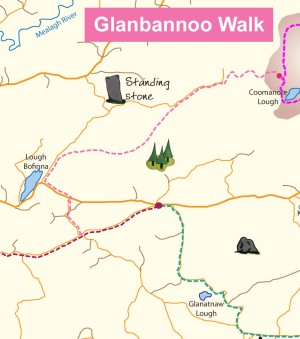
Glanbannoo Walk
Starting point: Coomanore Point
Duration: 1 hour 15 minutes
Distance: 5.5km
Difficulty: Moderate, mostly on track or road.
Direction: Westwards
An invigorating walk on bog road, valley and ridge with Loch Bofinna near its end. Starting at Coomanore point near the Lough, this walk continues westwards to meet the Bantry-Drimoleague section of the Sheep’s Head Way at Trawlebane Bridge.
St Finbarr’s Pilgrim Way
Stretching from the Top of the Rock, Drimoleague, to Gougane Barra, at a distance of 37km, this two day walk follows in the footsteps of St Finbarr who visited Drimoleague in the 6th century. The walk passes through Kealkill, taking in part of the Carriganass walks on the way. The walk is challenging in places (refer to the booklet ‘A guide to the Sheep’s Head Way – Eastern Routes’, Walks 1, 6, 8, 9 and 12, for more details).
