Dunmanway Hill Walking Trails
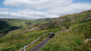
There are several well-designed walks, from easy to hard, to the north of Dunmanway. Each provides magnificent views of the rolling hills. Most routes are also suitable for cycling as they are on quiet country roads with little heavy traffic.
Yew Tree Hill Loop Walk
Distance: 9.8 km
Time: 4.5 hours
Category: Strenuous
This trail is waymarked with white on black background.
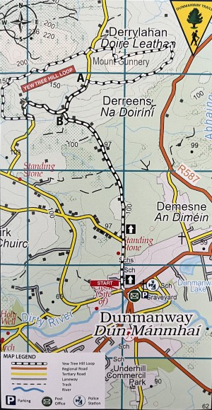
Due to parking restrictions on Main Street, it is recommend that you park at the car park near SuperValu off Main Street. From the car park, passing this point, set out up St Mary’s Road and follow the local road until you reach a point marked A on the map where the route leaves the road right and enters open mountain. This route goes eastwards over marshy land and rocky outcrops. Continue eastwards, climbing gradually until the route turns northwards and then westwards to reach the summit of Mount Gunnery (known locally as The Yew Tree Hill) at 231 meters O.D.
This point offers panoramic views over the town of Dunmanway and most of West Cork. The walk then descends northwestwards to reach the grotto on a quiet local road. At the grotto, cross the road and continue westwards over rough terrain until you reach the summit of this section of the route, all the time enjoying the scenic beauty of the countryside with Nowen Hill to the far west.
The route then descends by plantations of deciduous and evergreen woodland to reach another local road. The route turns left at this point to meet the local road (a point marked B on the map) on which it connects to Dunmanway Town. Follow this road back to the finish point from which you came.

Nowen Hill Trails
Each of these three trails starts at Cullenagh Carpark. To get there take the L4609 from Castle Street out of Dunmanway and follow the road signs for the Pipe Hill Trails. After 7km turn left and follow the L4611 road for 5km as far as Cullenagh Lake carpark.
Walk 1
Distance: 23 km
Time: 5 – 7 hours
Category: Hard
Nowen Hill at 530 metres O.D. is the highest point in the Dunmanway area. This walk starts among forestry and follows the road in a north-easterly direction turning left at Farnanes crossroad and passing a Standing Stone on the left just over the bridge. Standing Stones are thought to be ancient burial sites and are found in every county in Ireland. Follow the road northwards and then westwards with a gradual climb to reach the top of Barraboy where a splendid view of the Mealagh Valley and Bantry Bay can be enjoyed. Descending into the Mealagh Valley the route turns left at Mealagh Bridge and left again at Barnagullane to follow the steep winding ascent between the twin peaks of Mullaghmesha and Dirreenacrinnig. This ascent is rewarded with a magnificent view over the rolling hills of West Cork. The road descends sharply to pass beside the majestic Donovan Castle, seat of the Donovan Clan up to the sixteenth century. Turning left soon after the road leads through the pasturelands of Leitry with its Standing Stones and Stone Circles, and left again to reach the starting point overlooking the tranquil Cullenagh Lake.
Walk 2
Distance: 9 km
Time: 2.5 – 3 hours
Category: Moderate
This walk starts again at Cullenagh Lake and takes in Coolkelure, Dromdrastil and Cullenagh. It is entirely over tarred country roads. The route passes through the picturesque setting of Coolkelure with its tranquil Lake and Coolkelure House surrounded by rhododendron hedges. St. Edmund’s Church with its stained glass windows and Coolkelure lodge nearby are set in the most peaceful and tranquil surroundings.
Walk 3
Distance: 3 km
Time: 0.5 – 1 hours
Category: Easy
Walk 3 is the shortest of the three Nowen Hill Trail walks. This encompasses Annees Bridge and is classed as an easy walk for those who wish to avoid any strenuous climbing. Part of this walk is through forest paths and marshland so waterproof footwear is recommended.
Pipe Hill Trails
Each of these three trails starts at Coolmountain Crossroads, a short distance from Coolmountain Bridge. To get there take the L4609 from Castle Street out of Dunmanway and follow the road signs for the Pipe Hill Trails. After 8km turn right onto the R585 and at Togher crossroads (1km) turn left onto the L8542 road. Follow this road for almost 3km to reach Coolmountain Crossroads. Please note that each of these routes is also suitable for cycling as each is on quiet country roads with little heavy traffic.
Walk 1
Distance: 15 km
Time: 3 – 4 hours
Category: Hard
This trail is entirely over quite country roads and climbs steadily north-eastwards to reach the top of Knoockaunabipee. This location got its name from the practice of carrying coffins for burial in Inchigeelagh. Such was the extent of the climb that the coffin bearers stopped at this point to rest their heavy load and smoke their pipes. At the highest point of this trail can be seen various mountain ranges, including, to the west Shehy, Caha and to the north the McGillycuddy Reeks in Kerry with the Paps and Mullaghanish to the north overlooking Lough Allua in the Iveleary Valley.
The road drops down through Gortnahoughtee passing a Mass Rock where priests said Mass in Penal times. Turn sharp left onto the Beara/Gougane Barra Cycling route and follow the road along the south side of Lough Allua. Shortly afterwards turn left onto the Gortnacarriga road. The road rises gradually through Monavaddra to reach the crest of the hill at Mount Prospect. From here spectacular views can be seen over Dunmanway from Nowen Hill to the west to The Galley Head to the south. This winding country road descends sharply to Moneylea and leads back to the starting point through forest and low lying sheep grazing farmland.
Walk 2
Distance: 10.4 km
Time: 2.5 – 3 hours
Category: Moderate
From the same starting point take the road north-eastwards, turn right at the first crossroads and follow this road through quite hedgerows and farm pastures. At the second fork in the road you have a choice of completing the circuit in either a clockwise or anti-clockwise direction. Either route offers lovely views of the open countryside.
Walk 3
Distance: 3.2 km
Time: 0.5 – 1 hours
Category: Easy
This walk follows the same route as the previous two walks. At the first fork in the road turn sharp left and follow this road back to the Knockaunabipee Road. This route affords a magnificent view of Shehy Mountain with Coolmountain and Cousane to its left. Turn left again at the next cross-roads; this leads back to the starting point.
