Castletownbere
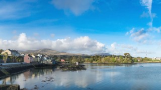
Castletownbere boasts possibly the finest natural harbour in Ireland. Nestling between the Caha and Slieve Miskish Mountains the town is sheltered from the Atlantic Ocean by Bere Island. Castletownbere is the perfect base for tourists to explore the unspoilt beauty of the Beara Peninsula’s flora and fauna and the many antiquities it has to offer. There is plenty of accommodation to choose from including bed and breakfasts, hostels and self catering as well as fantastic pubs where you’ll find fine food and an even finer welcome.
DIRECTIONS: Located on the R572, 51km from Bantry on the Glengarriff Road.
SPECIAL AREAS OF CONSERVATION: Pulleen Harbour Bog, Beara Peninsula.
About
The market square in Castletownbere is a joy to behold. Traditional and spacious this market hits its peak on the first Thursday of each month with a selection of top quality food and bric-a-brac. Throughout the summer various traders set-up each Thursday but to ensure a full market experience make the first Thursday of the month a must-visit. The market operates from 9am – 2.30pm.
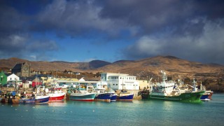
Fishing is the chief economic activity in the town but fishing only started up in a major way in the 1950s. Castletownbere is currently one of the five main fishing ports on the island of Ireland. It is the largest whitefish port in the country and the second safest natural harbour in the world. It is also home to the Irish Fisheries Training School, under the auspices of BIM.
Castletownbere is the main fishing port for south-west Ireland and it attracts visitors from far and near. A variety of colourful fishing boats, large and small, land their catches on the local pier. Some of the iced catch goes direct by road to Spain and other European countries. The rest of the catch goes to the local fish factories for processing and freezing before going to fish shops.
The town is the ancestral seat of Clan O’Sullivan Bere with Dunboy Castle, which was the site of the last battle in Ireland between Elizabeth I and the Gaelic Chiefdoms, within walking distance. The nearby Puxley Mansion was burnt down by the IRA in 1920.
Castletownbere Tourist Office is located in the grounds of the Church of Ireland in Castletownbere. The office is open 200 days a year and staff are always happy to offer help and information.
Discover the Locality
History
Over 500 archaeological sites and monuments are recorded in Beara indicating human activity going back over 4,500 years or more. They include wedge tombs, boulder burials, stone circles, standing stone rows, pre-historic copper mines, fulacht fiadh (prehistoric cooking sites), ringforts, souterrain etc. to name but a few. Many of the prehistoric sites are signposted along the Beara Way walking route. The spectacular remains of the castle of Dunboy was once the seat of O’Sullivan Bere.
How Beara got its name: According to the ancient annals, Conn Cead Cathach (Con of the Hundred Battles) fought a fierce battle against Eoghan (Owen) Mór, King of Ireland at Cloch Barraige in the early centuries AD. Eoghan was badly wounded in the battle. Those of his followers who survived took him to Inish Greaghraighe (now known as Bere Island) as a safe place for him to recover. There, the fairy Eadaoin (Aideen) took him to her grianán (bower) where she nursed him back to health. Nowadays, this part of Bere Island is known as Greenane.
Having fully recovered, Eoghan and his followers then sailed southwards until they reached Spain. While there he met and married the princess Beara, daughter of the King of Castille. Wishing to return to Ireland, Eoghan and Beara sailed north from Spain with a large army and landed in Greenane of the south side of Bere Island. Owen took his wife to the highest point on the island and, looking across the harbour, he named the island and the peninsula, Beara, in honour of his wife. Rossmacowen and Buaile Owen are named after Eoghan Mór. According to local tradition, Eoghan’s wife, Princess Beara, is buried in the west side of the valley between Maulin and Knocknagree Mountains.
Dunboy Castle
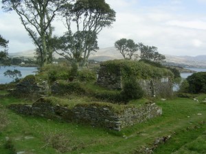
Dunboy Castle (meaning Caisleán Dhún Baoi) was a stronghold of the O’Sullivan Bere, a Gaelic clan leader and ‘Chief of Dunboy’. The castle, two miles west of Castletownbere was built to guard and defend the harbour of Berehaven. Its presence there enabled O’Sullivan Bere to control the sea fisheries off the Irish coast and collect sizeable taxes from Irish and Continental fishing vessels sheltering in the haven. It was also a centre for the import/export trade to and from the Continent. Today, much of the castle is destroyed but the ruins are open to the public.
Dunboy Castle was the scene of the famous Siege of Dunboy in the summer of 1602 which ultimately led to its destruction and the breaking of the power of the O’Sullivan Bere. At that time Donal Cam O’Sullivan Bere was in rebellion against the English crown and Elizabeth I had sent a 5000 strong army under the command of Sir George Carew to suppress the insurgents. Even with its small garrison of 143 men Dunboy Castle was thought to be impregnable but following a fierce artillery bombardment the walls were smashed and after some desperate hand-to-hand fighting amid the rubble the defenders were finally overcome. The 58 survivors of the two week siege were executed in the nearby market square.
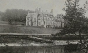
Near the castle ruins stands Puxley Mansion, a nineteenth-century manor house.It was burnt to the ground by the IRA in 1920 in reprisal for the destruction of houses that harboured IRA men and weapons by the Crown Forces. Plans to refurbish the mansion were halted in 2011.
Derreenataggart Stone Circle
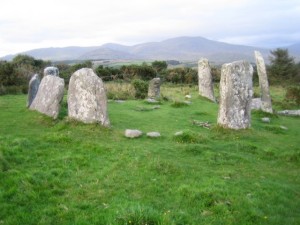
Derreenataggart Stone Circle is close to Castletownbere. Go to the Olde Bakery at the top of the town, take the road to the right and follow it up for about 2 miles (at the junction keep left). The circle is on your right. There is a small parking area on your left opposite the entrance to the field.
Cloontream Wedge Grave
Cloontream Wedge Grave stands high above Castletownbere. Follow the Beara Way from town. Behind the Millbrook Bar, take the first turn to your left and continue on up it until you come to a gate. Go on foot from here for about two miles and you will see it off to your left. Fine views can be had from it.
Things to do
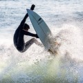
Along the magnificent coast of Beara there are centres for sailing, whale watching, swimming, angling, scuba diving, surfing and other water sports, with horse riding and lake/river fishing very popular inland. Other local activities like kid’s camps, island trips, and garden walks all make up the infinite variety that this region has to offer.
Walking
In 1990 the Beara Way Walking Route was set up. It is a route of 120 miles from Glengarriff to Dursey, Dursey to Kenmare and back to Glengarriff. The route includes Bere Island and passes through towns and villages on the Beara Peninsula. See The Beara Way under the Walking section.
Fishing and Angling
Fish the rich Atlantic waters surrounding the North and South of the Beara Peninsula, which influenced by the Gulf Stream, brings warmer water and exotic species of marine life to our shores.
Water Sports & Sailing
Should you crave adventure during the summer, look no further than taking part in water sports along the magnificent coast of the Beara Peninsula. Local companies provide a wide range of water sport activities.
Golf
The appetites of golf lovers are more than satisfied when they feast their eyes upon our lavish courses. Just outside Castletownbere is Berehaven Golf Club with a magnificent view of Bere Island and Berehaven Harbour. It is a nine-hole golf course. Glengarriff’s nine holes are in one of the loveliest settings in Ireland, with scenic views abounding – the one from the fifth tee is exceptionally beautiful. Bantry Bay Golf Club is an 18 hole championship golf course.
Beaches on Beara
Adrigole pebble beach is situated at Trafask (2.5 miles from Adrigole village on Glengarriff side) which is signposted from the main road. Another popular bathing area is the sandy inlet at Zetland which again is signposted from the main road.
Allihies: The beach at Ballydonegan on the way to Allihes village from Castletownbere was constructed using crushed stone taken from the disused Copper mines in the surrounding area. The beach also boasts an adjacent camping site with toilet facilities and is a short walk from the picturesque village.
Ardgroom: Droumard Strand is located 1.5 miles from Ardgroom Village on the Kenmare Road. It is one of the safest and cleanest in the Beara Peninsula.
Bere Island: A small sheltered strand is located on the South side of Bere Island overlooking Bantry Bay. It is signposted from the village Rerrin. It has sand a gravel beach and is safe for bathing for young and old.
Castletownbere: Tralahan, approximately half a mile (1 km) from the town on the main Allihes road, has been developed in the last number of years. Toilet facilities are now available. Take the first left turn, after the football pitch on your way out of the town on the Allihes road.
Eyeries: The Strand at Eyeries is signposted from the village. It has a sand and gravel beach and is safe for bathing for young and old. There are swimming lessons held during the summer.
Garnish beach is to be found at the tip of the peninsula en-route to Dursey Island. Comprising of fine white sand this beautiful beach also has toilet facilities. It is near Garnish Post Office and is well worth a visit on a sunny day in Beara.
Travara / Travaud: Both swimming areas are to be found on the northern side of the peninsula, between Eyeries and Urhan. They are popular bathing spots and host annual swimming lessons every year.
Tours
Southern Irish Lighthouse tour with John Eagle the author of the best selling book ‘Ireland’s Lighthouses A Photo Essay’.
Exciting 8 day tour of Irish Lighthouses from Inisheer to Hook Head, getting up close and personal with most of the major lighthouses on the South coast of Ireland. The tour is limited to 9 people due to the size of the boat for Bantry Bay tour of lights. For more information and how to book your place please visit: www.JohnEaglePhoto.com

