Coppeen Waymarked Walks
This is a series of walking routes around the Coppeen area, which is only a few kilometres north of Ballineen. Courtesy of www.coppeenheritage.com
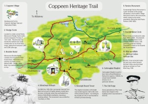
The walks system consists of four themed routes.
Fuchsia Walk
The Fuchsia Walk is a 6.6 km short distance walk, starting and finishing in the village of Coppeen. The route comprises entirely of way marked roadways, mostly quiet country routes, apart from the last section, which is along a short stretch of main road. The walk rises a distance of 100m at points on the route, and then descends back into the village, where parking and other amenities are available.
The entire route is marked by signage posts; this route being the fuchsia route, it is marked by red arrows. This walk gently ascends uphill for approx. 500m. A viewing point here (forestry plantation on each side) gives a wonderful panoramic view including; (South) Corran Hill, Carrigfadda, Nowen Hill, Shehy, Carrantuohill, Mangerton, The Paps, and Mullaghanish.
The road then winds along towards a four cross road junction (Slieveowen) where you take a right (house on left). Along this relatively level route admire the great views to the right, with fuchsia in profusion and larch forestry on left (neat standing stone in cottage garden on right). Turn right at the next ´T´ junction (ringfort on left) view on left towards Gurranareigh and Greenhill with valley sweeping down to the River Bride. Right at next junction, which ascends beyond forestry on right, looking across towards Lackanashinnagh on your left. Great view from the top of the hill: east to Cork airport and west to Shehy.
From here on it´s mostly downhill towards Coppeen village (Cross´s Forge last house on left – five generations of smiths traded here) Take great care as you walk along a short stretch of main road back into the village, admiring the wonderful view to the west.
Heather Walk
The Heather Walk is a 9.3 km short distance walk, starting and finishing in the village of Coppeen. The route comprises entirely of way marked roadways, mostly quiet country routes, apart from the last section which is along a short stretch of main road. The walk rises a distance of 150m at points on the route, and then descends back into the village, where parking and other amenities are available. The entire route is marked by signage posts; this route being the Heather route, it is marked by purple arrows. This walk leaves the village at the old Post Office and gently ascends uphill for a little more than 500m. A viewing point here (forestry plantation on each side) gives a wonderful panoramic view including; (South) Corran Hill, Carrigfadda, Nowen Hill, Shehy, Carrantuohill, Mangerton, The Paps, & Mullaghanish.
The road then meanders along towards a four cross road junction (Slieveowen) where you walk straight on up the hill. At a State Forestry roadway on the right, is the pathway to “Labbaowen” a wedge tomb, which is fighting for survival among the spruce trees. Approx. 300m further on, on your right you can see a fine boulder burial. The large round stone has several cupmarks on its upper face. Ignore a cul de sac on your right (a signage post directs you, just in case). A fairly level route takes you to the next crossroads; turn right here. (Tarelton village is approx 1 klm to the left).
Take a rest at the top of the hill (Barna) which is about 100m from the junction. Here you have a most splendid view, almost 360° around you. The hills of West Cork, Kerry, North Cork, and on a clear day Cork City and the Knockmealdowns, right around to the southern costal areas are all very visible. When rested, proceed along southwards along a pleasant relatively level road, plenty of heather to your left.
Then you descend Renacahera hill, crossing the River Bride, keep straight at little road to right into Munigave. Looking to your left you´ll see Gurranareigh and Greenhill, with a valley sweeping down to the River Bride. Turn right at next junction, which ascends beyond forestry on right, looking across towards Lackanashinnagh on your left. Great view from the top of the hill: east to Cork airport and west to Shehy.
From here on it´s mostly downhill towards Coppeen village (Cross´s Forge last house on left – five generations of smiths traded here). Take great care as you walk along a short stretch of main road back into the village, admiring the wonderful view to the west.
Fern Walk
The Fern Walk is an 8.3 km short distance walk, starting and finishing in the village of Coppeen. The route comprises entirely of way marked roadways, mostly quiet country routes, apart from the first and last section which is along a short stretch of main road, and at two points where a main road has to be crossed. The walk rises a distance of 130m at points on the route, and then descends back into the village, where parking and other amenities are available The entire route is marked by signage posts; this route being the Fern route, it is marked by green arrows.
Leaving Coppeen, you proceed eastwards (towards Cork), but after about two minutes you´ll see the first direction post on your left, which takes you on to a narrow road which meanders gently uphill, passing at the back of Cross´s Forge. Turn around to admire the view to the west, including Shehy and Nowen Hill. This route ascends for approx. 1km. Beautiful views from the top, particularly to the east and west. Then it descends for 1km. with very pleasant views of hill and valley. Keep to the right at two crossroads (watch our directional arrows) and next you´ll come to the main road (Bantry Line). Use extreme caution when crossing here. Watch for direction posts on both sides of the road. Then it´s an uphill walk for almost 1km.
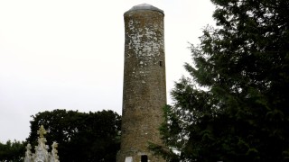
Take a pause just before reaching the highest point (red gate on left, new tree plantation opposite) and turn around. In the distance to the north you can see Carrantouhill, The Paps, Mullaghanish (TV Transmitter Mast) and closer, Lackareigh, Gurranareigh, Cleiragh, Cork City, Greenhill and Templemartin. When you have feasted your eyes and senses, proceed southwards, and take a right at next direction post. After approx. 100m pause at a gate on your left, before reaching the bungalow just ahead. Here you have a breathtaking view. All the hills and dales of the south west coast lie before you, stretching from Kinsale to Bantry. In the valley below, just a little to your right, notice historic Kinneigh Round Tower.
Corran Hill, Carrigfadda, Nowen Hill and Shehy dominate the skyline all around you. Continue walking to the west, ignoring two minor roads, first one to the left, and then one to the right, straight on, then a short steep climb, to another wonderful viewing point. Coppeen village lies underneath you to your right. The panorama to the west & northwest is quite superb – sit on the stone fence to your right and soak it in! Then it´s a steep downhill stroll to the village. Note a large house (now in a state of disrepair) on your left as you descend the hill. This is Coppeen House, where the local landlord Hungerford resided.
As you reach the secondary road at the foot of the hill, note a fingerpost pointing across the road to “Cahirvagliair Ringfort” well worth a visit. Then proceed along the road, past the National School and back to the village (be VERY careful when crossing the main road).
Gorse Walk
The Gorse Walk is a 12.4 km walk, and the longest way marked route in the area. The walk starts and finishes in the village of Coppeen. The route comprises entirely of way marked roadways, mostly quiet country routes, apart from two points where a main road (R585) has to be crossed (care should be taken at these points). The walk rises a distance of 150m at points on the route, and then descends back into the village, where parking and other amenities are available. The entire route is marked by signage posts; this route being the Gorse route, it is marked by yellow arrows.
This walk offers a variety of landscape features, combining farmland and domesticated land with natural bog lands, hedgerows, forests and streams. There are numerous viewing points also marked on the map, which take in panoramic views in all directions, including all the views listed for the other walks. These points take in views of: Corran Hill, Carrigfadda, Nowen Hill, Shehy, Carrantuohill, Mangerton, Cnoc Mhadra, The Paps, Mullaghanish, Clearagh, Cork City and many others. On leaving the village, be VERY careful crossing the main road. Then proceed along the Enniskeane road, where the road passes right through the middle of a ringfort just before the school. Take the next right if you´d like to visit the wonderful Cahirvagliair Ringfort. Otherwise, turn left just beyond the school, where the road ascends steeply for 500m. Notice Coppeen House on your right. Wonderful viewing point on top of hill.
Then proceed downhill before reaching a long relatively straight stretch of road. Just past a bungalow on your left, pause at a field gate on your right and enjoy an extraordinary view. Notice Kinneigh Round Tower in the valley below. It will seem like all South West Cork is at your feet! When you tear yourself away, walk east to a crossroad where you turn left. Walk on for approx 100m to yet another amazing viewing point (red gate on your right) Kerry´s Carrantouhill and the Knockmealdowns plus a wonderful panorama in between are visible on a fine day. Proceed downhill to the Bantry Line. Take great care when crossing here. 100m further on is a bridge, and just at the far side on the right stood a creamery in days gone by.
At the next junction keep left, and notice a ringfort in the field on your right. (If you take a right at this junction and walk for 400m you will come to Gurranareigh Famine Monument – well worth the trek) Then it's an uphill walk for 250m. You may see another ringfort in the valley to your right. The river Bride flows along this valley. Keep right at “Croisantailúir” then walk downhill and along to next junction, keep going straight. You may notice a ringfort in the field on your left overlooking the area. A pleasant little bridge over the river Bride leads you from Munigave to Renacahera & a steep hill, not very long though, thankfully! A good view from this point, and as you walk further north along, the views are very impressive.
Then you reach Barna, now here´s a view! You´ll have to spend some time here to savor the panorama. Then 100m further on take a sharp left and walk a relatively level route for approx 1500m keeping an eye on the wonderful views, particularly on your right hand side. You will come to a forestry plantation on your right and a short distance further on, in the field on your left you can see a wonderful Boulder Burial with cupmarks on its surface. Approx 300m further on, just past a cottage on your left is a forestry plantation roadway (with barrier) This leads to “Labbaowen” a wedge tomb. Walk straight through the next four crossroads, and it´s mostly downhill to Coppeen village from there.

