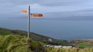
Sheeps Head Looped Walks
Sheep’s Head is home to villages of Durrus, Ahakista and Kilcrohane and is one of the quieter peninsulas in West Cork, hence it's popularity for walking.
Barán Loop
Distance: 9km
Grade: Moderate-Hard
Minimum Gear: Hiking boots, raingear, fluid, snack and mobile phone
Services: Ahakista, Kilcrohane (3km), Durrus (12km)
Terrain: Minor roadways, laneways, and mountain paths
Theme: Mountain
Starting Point: The village of Ahakista is located midway along the coast road between Durrus and Kilcrohane on the Sheeps Head peninsula.
Starting from the town of Bantry follow the N71 in the direction of Cork. After a little more than 1km turn right onto the R591 (signposted Durrus). After 4km pass through the village of Durrus and continue along the coast road for a further 5km to reach Ahakista. The trailhead is located at Arundel’s Public House on the right entering the village.
A-B. With your back to Arundel’s Pub, turn right and follow green (and blue and purple) arrows along the road for just 100 metres to the road junction where you turn right and, almost immediately, turn left onto a minor roadway. The blue and purple arrows are for the longer Seefin and Glanlough loops. Continue to follow this roadway to Gorteanish, taking note that you overlap with the long distance Sheep’s Head Way (yellow arrows and walking man) on the way. At a junction of laneways in Gorteanish the Glanlough Loop continues straight, you turn left and cross a stone stile, following the green (and blue) arrows.
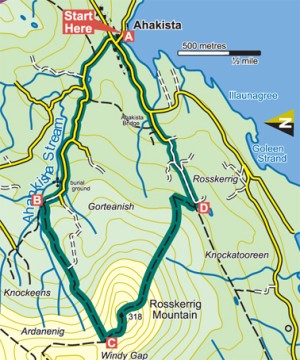
B-C. Now the loop starts the ascent of Ardanenig, easy along an old laneway at first and then a fairly steep climb on a mountain track for 400 metres to reach a point near Rosskerrig Mountain where the Seefin Loop turns right, but where you turn left.
C-D. Continue to follow the green arrows as the loop crosses Rosskerrig Mountain and descends to join the Sheeps Head Way on an old roadway where you turn left.
D-A. Now you follow green arrows (for this loop) and yellow arrows (for the Sheeps Head Way) along a surfaced roadway for over 1 kilometre before the Sheeps Head Way turns left at a memorial to Tom Whitty. Continue straight here and shortly afterwards join the main road for the peninsula. Continue straight at the junction, pass the pub with the tin roof on your right and reach the 3 way junction at A above. Turn right here, it’s only 100 metres back to the trailhead.
Seefin Loop
Distance: 13km/4hrs – 4hr 30mins
Grade; Hard
Minimum Gear: Hiking boots, raingear, fluid, snack and mobile phone
Services: Ahakista, Kilcrohane (3km), Durrus (12km)
Terrain: Minor roadways, laneways, and mountain paths
Theme: Mountain
Starting Point: The village of Ahakista is located midway along the coast road between Durrus and Kilcrohane on the Sheeps Head peninsula.
Starting from the town of Bantry follow the N71 in the direction of Cork. After a little more than 1km turn right onto the R591 (signposted Durrus). After 4km pass through the village of Durrus and continue along the coast road for a further 5km to reach Ahakista. The trailhead is located at Arundel’s Public House on the right entering the village.
A-B. With your back to Arundel’s Pub, turn right and follow the blue (and green and purple) arrows along the road for just 100m to the road junction where you turn right and, almost immediately, turn left onto a minor roadway. The green and purple arrows are for the (shorter) Seefin and (longer) Glanlough loops. Continue to follow this roadway to Gorteanish – taking note that you overlap with the long-distance Sheep’s Head Way (yellow arrows and walking man) on the way. At a junction of laneways in Gorteanish the Glanlough Loop continues straight – you turn left and cross a stone stile – following the blue (and green) arrows.
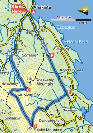
B-C. Now the loop starts the ascent of Ardanenig – easy along an old laneway at first and then a fairly steep climb on a mountain track for 400m to reach a point near Rosskerrig Mountain where the Barán Loop turns left – but you turn right.
C-D. Continue to follow the blue arrows as the loop travels north for 500m and then swings west (left) onto a ridge. Follow the ridge for over 1km to reach a trig stone atop Seefin Mountain (318m).
D-E. Just before the trig stone the loop turns sharp left and descends sharply to the townland of Derrucluvane. Joining a farm roadway turn right, pass through a farmyard, and watch for a stile on your left which takes you into farmland. Descending still the loop follows what was on old ‘mass path’ to eventually reach an old roadway where you turn left and rejoin the Sheeps Head Way.
E-F. Now you follow blue arrows (for this loop) and yellow arrows (for the Sheeps Head Way) along the old roadway for almost 2km. Here the Barán Loop (green arrows) rejoins from the left. Continue straight.
F-A. Joining a surfaced roadway follow the blue, green and yellow arrows for over 1km before the Sheeps Head Way turns left at a memorial to Tom Whitty. Continue straight here and shortly afterwards join the main road for the peninsula. Continue straight at the junction, pass ‘the pub with the tin roof’ on your right and reach the 3-way junction at A above. Turn right here – it’s only 100m back to the trailhead.
Glanlough Loop
Distance: 20km
Grade: Hard
Minimum Gear: Hiking boots, raingear, fluid, snack and mobile phone
Services: Ahakista, Kilcrohane (3km), Durrus (12km)
Terrain: Minor roadways, laneways, and mountain paths
Theme: Mountain
Trailhead: Ahakista
Starting Point: The village of Ahakista is located midway along the coast road between Durrus and Kilcrohane on the Sheeps Head peninsula.
Starting from the town of Bantry follow the N71 in the direction of Cork. After a little more than 1km turn right onto the R591 (signposted Durrus). After 4km pass through the village of Durrus and continue along the coast road for a further 5km to reach Ahakista. The trailhead is located at Arundel’s Public House on the right entering the village.
A-B. With your back to Arundel’s Pub, turn right and follow the purple (and green and blue) arrows along the road for just 100m to the road junction where you turn right and, almost immediately, turn left onto a minor roadway. The green and blue arrows are for the shorter Barán and Seefin loops. Continue to follow this roadway to Gorteanish – taking note that you overlap with the long-distance Sheep’s Head Way (yellow arrows and walking man) on the way. At a junction of laneways in Gorteanish the Barán Loop and Seefin Loop turn left and cross a stone stile – but you continue straight following the purple arrow.
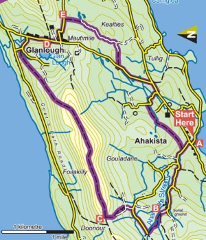
B-C. Follow the laneway for 500m to reach a surfaced road where you turn right. After another 500m watch out as the loop turns left on a right bend. From here the loop ascends onto a ridge at Doonour where it rejoins the Sheeps Head Way. Turn right.
C-D. Now follow the purple arrows (for this loop) and yellow arrows (for the Sheeps Head Way) for more than 7km along the ridge to pass Glanlough Lake and join a surfaced roadway. After 500m you reach a T-junction where both routes turn right, and another 500m takes you past a farmhouse on your left after which the Sheeps Head Way turns left – but you continue straight, staying on the surfaced road.
D-E. After only 300m you turn left at a road junction, walk for 500m and again join the Sheeps Head Way as you turn right onto a bog road.
E-A. The loop now starts the descent towards the trailhead – a 6km journey which passes through the townlands of Kealties and Tullig.
Lighthouse Loop
Distance: 4km
Estimated Time: 2 hours
Grade: Moderate
Start & Finish: Turning point car park near the end of Sheep’s Head
Terrain: footpaths, tracks and paved lanes
Suitable for reasonably fit walkers, this loop walk takes you on a circuit around the tip of the head, along sea-sprayed clifftops through rough and rocky terrain. The route starts from the carpark and continues along the road. Across Dunmanus Bay to the left undulating Three Castle Head can be seen 7 kilometres away stretching westwards to dip into the Atlantic, while the signal tower at Mizen Head is just visible in clear weather on the hill behind. The track the route follows reduces to a narrow path worn deep into the scant strips of turf remaining between ridges of bedrock: but for the telegraph posts that parallel the path the surroundings have a primitive and primordial quality. Soon the path crosses a little ridge and descends where an ancient stone wall wanders seemingly aimlessly, leading the eye towards the tiny reed-fringed Lough Akeen, nestling between fingers of rock.
The coast on the far side of Bantry Bay to the north comes into view now. In the foreground is Bere Island with a white column marking its northern tip, and behind it the Beara peninsula steps down past Blackball Head to Dursey Island at its tip. Scattered sheep glean nourishment here from the sparse grass and new shoots of heather and gorse, while the redbeaked choughs, rare birds elsewhere in these islands but common on Sheep’s Head, perform aerobatics among the crags along the clifftops. The rough path leads down to the tip of Sheep’s Head to reach the tiny lighthouse. This is a very modern installation, erected as recently as the late 1960s to assist the safe passage of the giant oiltankers using the then newly-built Gulf Oil Terminal at Whiddy Island.
Now our route leaves the lighthouse behind and turning northeast continues along a narrow valley between ridges of rock scattered with lichen-decorated glacial erratics. They were deposited unknowable years ago by a great ice sheet that must have covered the sea offshore as well as the land. As evidence of the unpolluted purity of the air here on the south west tip of Ireland, some rocks display coatings of map lichens, different coloured patches that look like a page from a geography book. Our route comes quite close to dramatic cliffs at times now, dropping down to seething surf and turquoise swells.
On the horizon beyond the eastern tip of Bere Island the rounded massif of Hungry Hill reaches up. Offshore gleaming white gannets with black wingtips can often be seen cruising the swells and diving headlong into the sea in search of fish. If you are particularly fortunate, you may catch sight of dolphins or even a whale, not uncommon in these waters. Soon after sighting the low pyramid of Caher Mountain 7 kilometres ahead, the route turns right and away from the cliffs.
The narrow interior of the head is crossed through a strange old landscape of little-used farmland with ferntopped stone walls dividing fields of bracken. Cattle graze the grass around the ruins of a stone cottage that overlooks the fields. Past this ruin the route reaches an old track, which takes it back to the starting point, where you can enjoy tea and delicious home-made scones and jam in the teahouse.
Cahergal Loop
Distance: 10km/3hrs – 4hrs
Grade: Hard – to suit average levels of fitness
Minimum Gear: Hiking boots, raingear, snack, fluid and mobile phone
Services: Kilcrohane (4km), Durrus (15km)
Terrain: Laneways, tracks and mountain paths
Starting point: The trailhead is located at the old Butter House in the townland of Letter on the Sheep’s Head Peninsula.
Starting from the town of Bantry (on the N71 in West Cork) follow the N71 in the direction of Cork. After a little more than 1km turn right onto the R591 (signposted Durrus). This coast road takes you through the village of Durrus (4km) and Ahakista (another 5km). Approximately 6km past Ahakista you reach the village of Kilcrohane – continue straight through it and travel a further 4km to reach the Butter House (old stone building) on your left.
A-B. Leaving the trailhead at the Butter House follow the blue (and green and orange) arrows and travel a short 30m before turning left onto a laneway. The green arrows are for the shorter Cahergal Loop, the orange arrows for the more difficult Peakeen Walk – a linear trail which crosses the mountains to Kilcrohane. Ascending quickly, the loop joins a green track and after crossing three stiles, enters an open field towards the mountains. Crossing a stile at the end of the field, the loops separate – the Ballynatra Loop and Peakeen Walk proceed straight uphill, but you turn left following the blue arrows.
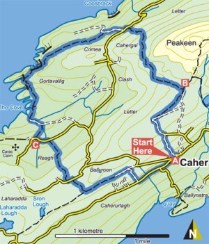
B-C. The loop now crosses a section of open hillside to reach a surfaced roadway in the townland of Cahergal. Here it crosses the road and joins the Sheeps Head Way (a long-distance trail marked with the familiar yellow arrows and walking man) for almost 3km along Gortavallig and the north coast of the peninsula. The loop and Way continue to overlap with each other to the end of a ‘green’ laneway in the townland of Reagh where the Way veers right – but you turn left onto a surfaced roadway.
C-D. After a short distance the loop turns right and crosses a stile into farmlands. Note that you are also following the red arrows of the Poet’s Loop – one of two loops that start and finish at the top of the peninsula. Ascend to reach another surfaced roadway, where you turn left again and shortly afterwards turn right across another stile and ascend to a ridge where you rejoin the Sheep’s Head Way. Here you turn left (and leave the Poet’s Way) and make your way along an old green road for approx 1km. At the end of this section the loop and Way turn right and descend to join the ‘main’ road where you turn left. After 200m the shorter Ballynatra Loop joins you from a roadway on your right. Continue straight ahead – it’s only 100m back to the trailhead!
Cahir Loop
Distance: 6km/1hr 30mins – 2hrs
Grade: Moderate – to suit all levels of fitness
Minimum Gear: Hiking boots, raingear, fluid and mobile phone
Services: Kilcrohane (4km), Durrus (15km)
Terrain: Laneways, tracks and paths
Starting point: The trailhead is located at the old Butter House in the townland of Letter on the Sheep’s Head Peninsula.
Starting from the town of Bantry (on the N71 in West Cork) follow the N71 in the direction of Cork. After a little more than 1km turn right onto the R591 (signposted Durrus). This coast road takes you through the village of Durrus (4km) and Ahakista (another 5km). Approximately 6km past Ahakista you reach the village of Kilcrohane – continue straight through it and travel a further 4km to reach the Butter House (old stone building) on your left.
A-B. Leaving the trailhead at the Butter House follow the green (and blue) arrows and travel a short 30m before turning left onto a laneway. The blue arrows are for the longer Cahergal Loop, the orange arrows for the more difficult Peakeen Walk – a linear trail which crosses the mountains to Kilcrohane. Ascending quickly, the loop joins a green track and after crossing three stiles, enters an open field towards the mountains. Crossing a stile at the end of the field, the loops separate – the Cahergal Loop turns left, but you proceed straight uphill following the green arrows (and the orange arrows for the Peakeen Walk).
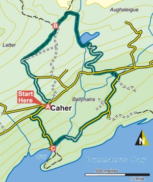
B-C. Travel a short section uphill before turning sharp right and starting downhill – leaving the Peakeen Walk as you do so. Descend to reach a stile onto a sandy laneway. This laneway takes you by a corrie lake, and zigzags its way to join a surfaced roadway. Turn left here.
C-A. Almost immediately, you turn right again and follow narrow laneways towards the coast. The loop passes through the townland of Ballynatra and crosses farmland to reach the pier at a narrow surfaced roadway. Here you swing right and uphill following the surfaced roadway back to the main road. Joining the main road, turn right and enjoy the last 100m back to the trailhead.
