Bantry’s Heritage Loop Walks
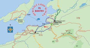
Bantry has a wealth of heritage, natural and built, from sea, woodlands and mountains, to Bantry House, the Kilnaurane Pillar stone and story of Wolfe Tone. The aim is to take walkers on a tour of many of the heritage points of interest in and around the town.
The walks vary from 2.5m to 5km plus, but they can be linked together to form a walk of more than 20km. Most of the walks use pavements, paths and small roads, so are suitable for all the family. For the more adventurous there is the possibility of striking out across the peak of Knocknaveagh, which provides stunning views over the town and bay. The walks are complemented by a series of interpretative boards erected by Bantry Tourism, Failte Ireland and Cork County Council.

Abbey and Rope Walk Loop
Starting point: Tourist Office, Bantry Square
Length: 4km plus short side trip to Kilnaruane Pillar stone.
Climb: 50m
Difficulty: Easy
Colour Code: Blue
The walk follows the pavement along the southern side of Bantry Bay, passing the entrance to Bantry House, the fishing pier and the Abbey graveyard, which has monuments and memorials erected to those who have lost their lives at sea. Turning left after the Westlodge Hotel onto the Rope Walk Road, the loop includes a short side trip to the unique seventh century Kilnaruane Pillar stone, which features a very early depiction of a boat. The route can be varied by taking a walk up through Bantry House’s gardens and woodlands to reach the Rope Walk or by wandering along a track through the Westlodge Hotel grounds, passing an intertidal pond.
Béicín Loop
Start Point: Tourist Office, Bantry Square
Length: 2.5km
Climb: 30m
Difficulty: Easy (pavements and paths)
Colour Code: Purple
The walk passes St Brendan’s Church and continues along the northern side of Bantry Harbour, with its flocks of gulls and parties of mute swans. Passing the site of the former railway station, you reach the old railway pier. After the pier, a new promenade runs along the sea front, backed by banks of gorse (furze). Marine animals to look out for include terns, which breed on nearby Horse Island, and harbour seals. The walk loops back to the start point via the streets and back-roads of Bantry, partially following the route of the old railway which existed in Bantry until the 1960s.
Knocknaveagh and Vaughan’s Pass
Start Point: Tourist Office, Bantry Square
Length: 5km round trip, plus the option of an additional 5-10km.
Climb: 170m (or 280m if continuing up Knocknaveagh)
Difficulty: Easy (pavements and small roads) to medium (good walking boots required for Knocknaveagh).
Colour code: Orange
The walk takes you to a viewing point high above Bantry Bay with fantastic panoramic views over the town and across the bay to the mountains beyond. The route climbs up through Bantry, past the post office, up Scart Road and through Dromleigh before following a pretty winding road all the way up to Vaughan’s Pass viewing point. From the viewing point you can strike out across the open heath of Knocknaveagh, following the Sheep’s Head Way route. At the far side of the hill there is the option of making the walk a loop by returning to Bantry by a 7km road route, passing the Captain O’Neill monument along the way. Otherwise retrace your steps.
Donemark Loop
Start Point: Peace Park
Length: 2.5km
Climb: 15m
Difficulty: easy
Colour Code: Green
Starting at the Peace Park, which is a small formal garden owned by Cork County Council with a fledgling community orchard planted by Sustain West Cork, the route heads out of town along the pavement. Along the way there is a plaque, which marks the site where a Priest´s horse reputedly leapt from a pass above Coomhola 16km away. At area where the two bridges cross the Mealagh River, is Dún na mBarc or ´fort of the ships´ where the first people to arrive in Ireland are thought to have landed. The walk loops back following part of the original Glengarriff road before the new bridge and road was built in the late 1830s.
Lady’s Well and Airstrip Loop
Starting Point: Westlodge Hotel
Length: 5km (Airstrip only, 1km)
Climb: 50m
Difficulty: Easy, good walking boots recommended for off road section
Colour code: Red
The first half of this walk features lovely views over Bantry Bay and an interesting religious site known as Lady´s Well with a mass rock dating from penal times. After Lady’s Well, small country roads bring you down to the seashore, where there is a little used airstrip and great views across to Whiddy Island. Here there is a pretty shingle beach and a clay cliff ‘Blue Hill’, which is part of a drumlin formed by glacial action. Look out for birds such as oystercatcher, turnstone and cormorant. At LOW TIDE ONLY it is possible to continue right along the stony beach to emerge at the new slipway by the Abbey graveyard.
