Schull & Mizen
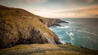
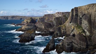
The Mizen Peninsula, at Ireland’s most south-westerly point, is renowned for the beauty of its rugged landscape and ancient heritage. A tour of the Mizen Ring gives you the chance to immerse yourself in the various strands that make the Mizen unique – from geology, flora, birds and fauna to the influence of man and his history on the landscape.
Directions
Located on the R592, 107km west of Cork city, 23km west of Skibbereen.
Special Areas of Conservation
Roaring Water Bay, Three Castle Head to Mizen Head, Barleycove to Ballyrisode Point, Derreenatra Cutaway.
Schull
The largest village on the peninsula is Schull. Set in the centre of an area of outstanding natural beauty, the village is one of the loveliest in West Cork. The prevailing southwesterly winds come over more than two thousand miles of open sea and the air is marvellously clear and clean. The safe and welcoming harbour, the many islands off-shore and the Atlantic Ocean beyond provide an excellent base for water sports. There is also tennis, pony trekking, a planetarium, fine restaurants, quality accommodation, a boatyard and a weekly Country Market. Schull also has a great selection on shops and boutiques to spend an afternoon pottering around.
A focal point of the village is Cadogan Strand or Trá na Oileáin, which was transformed by celebrity gardener Diarmuid Gavin, gold medallist at Chelsea Flower Show, from a rough piece of land overlooking the beach to a contemporary garden space. Ideal for picnics, Cadogan’s Strand is maintained by a devoted group of locals.
Established by the local producers including Gubeen Farmhouse, Schull market attracts a wide range of traders and visitors alike. This market is a real Sunday treat. Once the Sunday Mass bell tolls the market is suddenly swamped with tourists and locals alike. Local crafts, hot food, breads, organic veg, cakes and picnic basket fillers make up some of the selection fare here. The market operates from 9am – 2.30pm.
Travelling west from Schull you drive along the bog road built originally in the eighteenth century to carry butter to Cork for export to the new colonies.
Toormore
As you approach Toormore on your left you will see the Altar Dolmen, a Neolithic tomb. On the right just after that is The Altar Church built during the Famine as relief work. In the grounds of the Altar Restaurant a recent find was a Wedge Tomb from the Bronze Age.
Goleen
Continue on through the town lands of Kealfadda, Ballyrisode and Ballydevlin until you reach Goleen. This village was built during the nineteenth century at a crossroads where a cattle fair was held. You will see that the street is very wide and all the houses were originally built as shops. There is a hidden harbour at Heron’s Cove, down to the left in the village, which gives the village its name ‘Goilín’, ‘little inlet’. Although the harbour dries at low tide, giving great feeding for a variety of wildlife including a fox and a pheasant, there is a deepwater quay at the entrance to accommodate fishing boats and yachts.
Crookhaven
Crookhaven Harbour is as picturesque as it was useful being a large sheltered harbour. You pass the old Roadstone Quarry on the side of the mountain, which provided metalling for the roads of Wales until 1945. There are numerous Bronze Age field monuments in the hills around Crookhaven. The Ordnance Survey Discovery Series map 88 will indicate their whereabouts for you. The village of Crookhaven has a distinguished history as the last port of call for ships going to and from America.
Over the centuries ships stocked up with provisions here before tackling the Atlantic Ocean. All the shipping lines had agents here to tell the ships in which port their cargo had been sold. In the late 1900s it was said that you could cross the harbour on the decks of boats. 700 people lived and worked in the village against the 29 permanent residents today. Marconi came here to try to get his first radio message across the Atlantic and he fitted the first telegraphic equipment to the Fastnet Rock Lighthouse to communicate with the passing ships.
Brow Head
On your way back to Barleycove, you can take the road up to Brow Head from Galleycove beach. Looking back east from the top of Brow Head you can see Roaringwater Bay, Cape Clear and some of Carbery’s Hundred Isles. The Signal Tower was part of a chain built in 1804 in fear of a French invasion to give fast communications all round the coast. The original signalling was done with a system of flags and blackballs on masts. Brow Head or Mallavogue was a vibrant mining area in the nineteenth century and you can still see the remains of the mines and the miners’ houses.
Barleycove
Barleycove is a large sandy beach backed by sand dunes. The sand dunes were thrown up in the tidal wave that swept Europe after the earthquake in Lisbon in 1755. Today they have been partially eroded but they are protected like much of the coast round this area as European designated Special Areas of Conservation. The road goes to the east of the beach across a causeway bisecting Lissagriffin Lakes and at the T-junction you turn left to Mizen Head.
Mizen Head
Mizen Head Visitor Centre has been developed by a local tourism co-operative at ireland’s most southwesterly point. They have a lease on the Irish Light Signal Station, which was built in 1905 to protect shipping from the cliffs in fog. It is a spectacular location with its folded rocks and high cliffs. The Signal Station is on an island joined to the mainland with a fine example of an arched bridge. If you have plenty of puff you can go up the 99 Steps but there is a path for the less energetic!
Three Castle Head
Another gem of the Mizen Peninsula is Three Castle Head where the Three Castles, which are three Tower Houses with, curtain walling. Built in the 15th. Century on the site of a Bronze Age Promontory Fort, the Castles stand sentinel beside a cliff top lake. Access is restricted at the moment because of the unstable state of the castles, but it is worth asking if it is possible to visit.
Dunmanus
Continuing the journey round the Mizen Ring, you take the road back towards Goleen and turn left onto the Coast Road by Lissagriffin Lakes. As you wind up the road the view to the north suddenly opens up to show Dunmanus Bay, Sheep’s Head and in the distance the Beara Peninsula and the mountains of Kerry. Looking down to the sea you pass Dhurode Copper Mine with the round stone built Explosives Magazine. All along the road you will see signs of the mines. You reach Dunmanus Castle, an O’Mahony stronghold from the 13th. Century, beside the little harbour. A short drive from there takes you back onto the Durrus/Bantry road.
Information courtesy of www.schull.ie and www.mizenhead.net
Discover the Locality
History
Marconi in Mizen
Guglielmo Marconi came to the Mizen peninsula at the beginning of the 20th century to try to get his first radio message across to America. Desperate to get a signal across the Atlantic Ocean, he was searching for a suitable site for his masts and he came to Crookhaven. He erected a high mast in the grounds of the presently named Marconi House, but he didn’t have any success with it. However, this did not end his connection with Crookhaven. In 1902 Marconi brought wireless operators from England with him and a telegraphic station was established in the village using a coherer receiver.
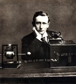
In 1904 Marconi’s Wireless Telegraph Company entered into a contract with the Commissioners of Irish Lights to put telegraphic equipment and aerials on the Fastnet Rock. The telegraphic station was moved up to Brow Head. At first messages were sent to the Fastnet Rock Lighthouse from ships by signalling methods and then relayed to the Brow Head station by wireless telegraphy where they were further relayed on to the intended recipients.
At first, very few ships had telegraphic equipment on board but the development in wireless telegraphy was gaining pace so quickly that the operators were never bored. There were six operators who had to make the lonely trudge out of the village and up the hill to Brow Head to the former Lloyds station. There were three watches – midnight to 8 am, 8am to 4pm, and 4pm to midnight with two operators on each watch. In 1904 a ship broke a shaft eighty miles out from Crookhaven. She was fitted with Marconi equipment and soon hundreds of messages were streaming back and forth to her as the passengers contacted their families and friends. Assistance was sent immediately and she was back on course without mishap. Marconi’s invention had taken much of the fear out of the sea.
After Marconi had conquered the transatlantic message and more shipping lines equipped their fleets with Marconi equipment, it was not necessary to be close to the shipping lines or to man a station in a remote area like West Cork and the station closed. The role of Crookhaven as a communications and provisioning hub was over and it reverted to a quiet fishing port. However, it has never lost its cosmopolitan appeal. In 1998 Elletra Marconi, Guglielmo’s youngest daughter by his Italian second wife visited Crookhaven to see for herself the place where her father had worked at the beginning of the century.
The Fastnet Lighthouse
The Fastnet Lighthouse, southwest of Mizen Head, is known as The Teardrop of Ireland, the last sight of Ireland for emigrants sailing to America. The Fastnet Rock is two pinnacles of hard clay shale with veins of quartz rising to a height of 30m above low- water mark surrounded by deep water.
The Corporation of Trinity House sanctioned the first lighthouse, a cast iron tower designed by George Halpin, in 1848 to replace the Cape Clear Lighthouse, which was too far inside the dangers, too high and too foggy. The Tower was finished in 1853 and the light first shown on January 1st. 1854. The total cost, including three dwellings built at the entrance to Crookhaven Harbour to house the Lightkeepers’ families, was £20,000.
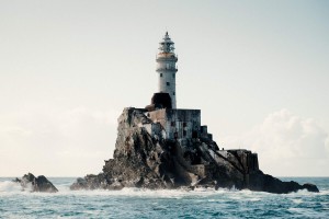
In 1891 the Irish Lights Board resolved that the light on the Fastnet was not powerful enough for its position as the principal landfall light on the southwest coast. They applied to build a new tower to make it the best possible light. The cost was estimated at £70,387.
The diameter of the base of the tower to 52 feet and the entrance floor is at a height of 57.75 feet above high water. Above the entrance floor the masonry of the tower extends to a height of 88 feet. It is divided into seven rooms with granite floors. The first floor room is the Storeroom. It contained the magazine for storing the gun cotton for the fog signal. The second floor room was the oil-room with oil tanks and a pump for forcing the oil up to a small supply tank in the lantern.
The third floor room was a spare bedroom for workmen. The fourth floor room was the principal storeroom with presses and shelving. There was a special felt lined cupboard for storing the detonators for the fog signal charges. The fifth floor room served as a kitchen with a cooking range, a circular table, a bookcase, shelving and a white glazed stoneware washing up sink. The sixth floor room was the bedroom for the lightkeepers with bunks, a wardrobe, lockers, shelves and a rail with sliding hooks. The floor was covered with cork carpet.
The top storey was a service room with a cast iron rainwater tank, which collected the water falling on the lantern and upper balcony, the wireless telegraphic instruments, a sink, a wash-hand-basin, cupboards and shelves for light room utensils and stores. The windows were louvred to give bottom ventilation to the lantern.
The ‘SS Ierne’ was specially built for carrying the stones for the tower. At the Rock, the stones were lifted by means of a series of pulleys and masts.
James Kavanagh, the foreman, joined the project in 1896. He was to stay with the construction on the Rock until the last course was finished in June 1903. He went ashore at the end of June complaining of sickness. He died in July and was taken for burial in Arklow on the Irish Lights’ vessel. He had personally set every stone on the Lighthouse.
Bad weather and the difficulty of finding suitable stone delayed construction. During the summer months 11 – 15 men lived on the Rock in addition to the foreman with 4 – 6 extra hands being landed on any day that stones were set. In 1899 when the rock was being cut for the foundations as many as 22 men lived on the Rock, not counting the Lightkeepers.
An office, stores, carpenters’ and blacksmiths’ shops, a barrack for the workmen and two keepers’ dwellings were built on Rock Island, giving work to the men when the weather was too severe for work on the tower
The characteristic of the light and its apparatus was finally decided by the Irish Lights Board in February 1902. The character adopted is a single flash every 5 seconds. The power of the beam through the lens for the centre of the flash is about 750,000 candlepower. The light floats in mercury, which enables it to revolve evenly.
In 1904 The Marconi Wireless Telegraphy Company installed wireless telegraphy equipment and signal-flag masts on the roof of the lantern to contact passing boats. Mr. Rickards, the Marconi Company’s Engineer, stayed on the Rock for some months to instruct the light keepers in the use of the apparatus and to experiment with several aerials. The Rock was used as a regular Lloyd’s signal station, receiving flag-signals from passing ships and telegraphing the messages ashore to the Brow Head Station.
J. Kavanagh, son of the foreman, proceeded to dismantle the old tower in March 1904.
A temporary light was installed while the work proceeded. In 1903 a storm damaged some of the lantern parts, but by April 1904 repairs had been made in Birmingham and the lantern returned to Rock Island, but it was not until June 25th. that the lantern and burners were ready.
The Commissioners came to Crookhaven on board the Irish Lights’ Steamer SS Alexandra to inspect their new light. They were delighted with the intense flash of the light at 22 miles distance.
There were six Keepers at the Fastnet Rock – four at a time and two on leave. Reliefs were twice a month when two men were taken off. Each man did four weeks on two weeks off. One man had to stay on watch during daytime to look out for fog and to signal passing ships. As soon as fog was seen another man was called up to work the fog-signal.
The annual cost of maintenance and repairs was about £1000. Lloyds repaid £200 to the Commissioners for the services of a lightkeeper. The cost of oil, mantles, etc. for the light was about £45 and ammunition for the fog signal was £260 p.a. The SS Ierne was retained for service at other stations in the southwest.
Mount Gabriel
Mount Gabriel at 407m is the highest hill in the Mizen/Sheeps Head area. It is a place of great natural beauty with extensive views over Roaringwater Bay.
Mount Gabriel was an important source of copper in the Early Bronze Age. Scattered amid the rocks and blanket bog of the mountain’s eastern and southern slopes, are the remains of over 30 individual copper mines driven in sedimentary (old red sandstone) copper beds invaded by quartz veins. These date from between 1700 and 1500 BC.
Ireland was one of the main sources of Bronze Age copper which was used in the production of various metal items including axes, the high status symbols of their day, and Mount Gabriel was one of a number of sites that were once hives of industrial activity. Excavations here by one of Europe’s foremost Bronze Age archaeologists, William O’Brien of Galway University, has revealed evidence of mine workings, spoil heaps, mineral processing areas, stone axe manufacture and wood preparation areas. Artefacts recovered from inside the Mount Gabriel workings include smooth oval shaped stone mauls used to excavate the rock.
These would have been specially transported inland from the coast some 4 km away. Fragments of wooden tools were also recovered (predominantly of oak, hazel and alder) and were identified as picks, wedges, axe hafts, withies (used as binding on stone axes) shovels and planks. Significant quantities of charcoal was found both inside the workings and on the spoil heaps close to the entrances. The workings at Mount Gabriel were excavated by means of fire setting that consumed vast amounts of round-wood felled in the immediate vicinity and such activity led to the beginning of the destruction of Ireland’s ancient tree cover.
Parking at the Barnancleeve Gap, visitors to the mountain can find the mines, a series of inclined drifts to the right of the small stream that flows down the eastern slope, betrayed by the proximity of fragments of broken quartz where the mineral was processed. If you are lucky you can find the broken remains of maul stones used to ‘spall’ (crush) the mineralised rock on anvil stones. The mines range in size from 1m to 12m in depth; some are flooded or choked with peat but one or two are still open and, although a little muddy, it is possible to crouch through the narrow entrance void and travel back through time into these ancient workings. These evocative caverns bear the unmistakeable scalloped patterning of workings excavated using fire setting to break the rock and the walls are streaked in places with the tell tale turquoise copper carbonate mineralisation.
Dunlough Castle
Dunlough Castle, standing atop the cliffs at the northern tip of the Mizen Peninsula, looks at the Atlantic Ocean from the extreme southwest point of Ireland. Founded in 1207 by Donagh O’Mahony, Dunlough is one of the oldest Norman castles in Ireland and an interesting example of Norman architecture and dry stone masonry.
Dunlough Castle is a series of three fortified towers, or keeps, which stand almost invisibly upon the isthmus connecting “Three Castles Head” with the mainland. The only route of access is from the south, and the castle appears suddenly as you cross through the hills onto the isthmus. The towers are connected by a wall spanning more than one hundred feet from the western cliffs to the shores of an apparently man-made lake. The wall is mostly fallen today; yet in places it stands approximately 15 feet (4.6 m).
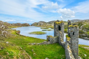
At the eastern shore of the lake, a wall from the same period serves as a dam, preventing the lake’s water from pouring over the cliffs into Dunmanus Bay several hundred feet below. Passage around the eastern shore of the lake is awkward; while the castle and wall block the western shore. Only a small footpath between the westernmost ruins and the 400-foot (120 m) cliffs allows travellers to visit the towers and the rocky cliffs beyond. As one writer has observed, “To an invading army, the cliff’s edge, the defensive wall, the lake and the sternly inaccessible approach would have made the castle appear impregnable.” It is not known if Dunlough was ever attacked.
At the time the first Norman soldiers and settlers arrived in Ireland in 1169, the O’Mahonys were the declining but still powerful princes of Eóganacht Raithlind, occupying approximately the area from Cork City west to Mizen Head.Their regional prominence had been diminished greatly since the MacCarthy dynasty had come south from Tipperary in the early 12th century, and faded even more rapidly as the Normans took hold of southern Ireland.Their primary Irish rivals (and allies) were the McCarthys and the O’Briens. But all these groups were militarily outclassed by the Normans who followed in the wake of King Henry II’s initial invasion.
In 1177, King Henry of England granted “the kingdom of Cork” to the Cambro-Norman knights Robert Fitz-Stephen and Milo de Cogan. De Cogan received the lands of west Cork, and began a push toward the Atlantic which drove regional families from the holdings in central Cork. The O’Mahony clan, led by their chieftain Donagh “the Migrator,” settled at the furthest point, the tip of the Mizen peninsula.
As an example of dry stone masonry, Dunough is unusual in that it features three towers with distinct designs, each rather smaller than the typical solitary towers of the region. Designed to fit its environment, the three keeps and the connecting wall would have been a daunting target for invading armies, though it is unknown if any ever attempted to take the castle.
Each keep is three stories high, typical of rectangular towers of its day. No turrets or parapets are present among the remaining structure. The eastern keep was probably the gate tower, though the gateway itself is today in ruins. The western tower is the largest, and was most likely the residence for most of the inhabitants. Typical of “sub-towers” found in larger Norman castles, the central keep provided additional lookout and storage, and served to reinforce the strength of the connecting wall.
Dunlough’s interior design is in keeping with other early Irish castles. The presence of a spiral staircase in the eastern tower is offset by the linear staircases of the western tower, while the central tower encorporates both types of stairs. The spiral stairs of the eastern tower are today visible from the outside, due to the crumbling of the outer walls. The simple, rectangular towers of Dunlough foreshadowed the regional castles which were built in later years, many of which still stand. Plain and unornamental, these castles, many of them O’Mahony keeps, rise from the landscape along both shores of the Mizen peninsula.
A common characteristic of the O’Mahony castles, evident at Dunlough’s western keep, is the second-storey door. Usually directly above or just to the side of the first-storey entrance, the second-storey door was probably accessed by means of a removable wooden ladder. Inside, the door leads either forward to the second storey (commonly wooden) or upward through the wall to third level. The third storey at Dunlough, as at other O’Mahony castles, is a stone floor which served as the banquet and gathering hall. This was a common feature of most Norman keeps from the early period.
Dunlough’s deterioration is attributable in part to the dry stone masonry used in its construction. This method is unusual for castles in this area, which, built in later years, made more use of wet mortar and sand. Yet the use of dry stone masonry was common in earlier Irish buildings.
Things to do
Schull Harbour
The safe and sheltered Schull Harbour is home to many waterborne activities. Schull has a busy fishing fleet and a modern fish processing plant. Ferry trips to Cape Clear and Sherkin leave the pier daily throughout the summer.
There is a thriving local diving club and visiting divers may join them for a dive. Sea angling trips can be arranged on the various private motorboats operating out of the harbour. There is also canoeing, with tuition and rental of canoes available throughout the summer.
Schull Harbour is the home of an active sailing club, which organizes weekend races for both cruisers and dinghies throughout the summer. Visiting yachtsmen are invited to take part in all events, including the Schull Harbour Regatta, which is now the high spot of a week of active racing in and beyond the harbour. This week of racing is known as Calves Week and has become a major event in the Irish racing calendar, attracting many boats and crews who participate in the week’s racing. The Fastnet International School’s Regatta, an annual event held in July for young sailors from all over Europe and the world has become a concrete addition to the excellent reputation Schull has achieved within the international sailing community.
Walking around Schull
There are numerous pleasant walking routes around Schull graded from very easy to cross country up a mountain. See Schull Walks under the Walking section.
Schull Planetarium
Schull Planetarium, part of the local Community College, is the only Planetarium in the Republic of Ireland and provides a unique educational resource. The 70 seat Planetarium has a beautiful situation beside the harbour and in the shadow of Mount Gabriel.
On the Planetarium’s 8 metre dome, the Carl Zeiss single sphere sky projector shows an accurate representation of the night sky from anywhere in the northern hemisphere.
The Starshow is the main feature. It is a must-see for those of all ages whatever their interest in Astronomy and the stars. The present starshow format is the product of years of refinement, and is aimed at both entertaining and educating all, from the youngest to the oldest, and from the veteran astronomer to the novice.
The show consists of three elements beginning with a short video presentation. This is intended firstly to entertain and educate, and also to allow the audience’s eyes to adjust to the low level of light necessary for the show.
The main part of the show consists of a guided tour of the constellations to be seen at a given time. The night sky projected is an accurate representation of the starscape visible at the time of year. As a result, a Winter Starshow will be almost completely different in content to a Summer show. However the projector allows the freedom to navigate easily between the Winter and Summer night skies and all the constellations visible from the pole to the equator . Also included is a variety of observing advice, and astronomical mythology and anecdote, at the lecturer’s discretion. Different lecturers will bring their own unique perspective to the show, ensuring that Starshows are always fresh and original.
The final section of the Starshow is the Questions and Answers session. The audience can ask for information on anything from Red Giants to shooting stars, or to be shown any one of the 88 constellations. The Lecturer will endeavour to answer any questions asked. Schull Planetarium is one of the last planetaria in Western Europe to retain this interactive element, and is very anxious that it should be retained. Audiences are actively encouraged to participate, and many after-show discussions have proved most stimulating, both for lecturer and audience.
Each Starshow lasts for approximately 45 minutes.
Times: June – Mondays 8pm, July & August – Mondays & Saturdays 7pm, Wednesdays & Fridays 5pm.
Whale & Dolphin Watching
Coastal waters off the southwest of Ireland are a summer feeding ground for a number of whale species and a year round home for several resident dolphin species including the Harbour Porpoise. Baleen Whales are commonly seen in the clear, unpolluted West Cork waters including Fin Whales and Minke Whales.
Humpback whales are also seen off the southwest coast. These large marine mammals feed in Irish waters for over seven months of the year on a variety of small shoaling fish and may be seen just a few kilometers offshore.
Beaches on Mizen
Mizen has lots of beaches, coves, piers and inlets which are suitable for swimming but here are the most popular.
Barleycove is a sandy beach is situated between two headlands and comprises an extensive dune system. There is an interesting floating bridge in place to manage visitor access and reduce impact on natural surroundings. Barleycove is a proposed Special Area of Conversation and Natural Heritage Area. This beach is lifeguarded on weekends during the bathing season (lifeguard times are displayed on the information noticeboard at the beach).
Barleycove beach is quite remote. To get there take the R591 south west towards Toormore. At Toormore follow the signs for Goleen (R591). After a few miles you will come to a junction with one road heading for Crookhaven, the other road will take you to Barleycove. Ballyrisode Beach at Toormore has a Green Coast Award.
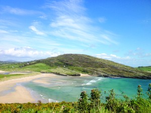
Galley Cove Beach, 1.5km west of Crookhaven Village is a safe and sheltered location for swimming and other recreational activities.
Cadogan’s Strand at Schull has a Green Coast Award.

