Kinsale
Take one spectacular location, season liberally with Norman, Spanish and English influence, add one major battle and let simmer for 400 years. The result… Ireland’s ‘Fine Food Capital’. But, the medieval town of Kinsale is not just about food, it’s about traditional bars, beautiful buildings, narrow streets, shops and galleries and lots of activities on sea and land.About
DIRECTIONS
Located on the R600, 27km southwest of Cork city.
About
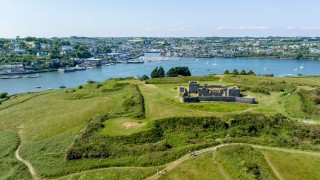
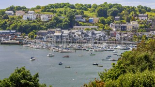
Originally a medieval fishing port, historic Kinsale (from the Irish, Ceann tSaile — ‘Head of the Sea’) is one of the most picturesque, popular and historic towns on the south west coast of Ireland. Visitors to Kinsale are captivated by its beautiful setting; its long waterfront, yacht-filled harbour, narrow winding streets and brightly painted cottages and displays of flowers. Compass Hill rises sharply behind the town and the impressive fortifications of Charles Fort and James Fort guard the narrow entrance from the sea – giving clues to its rich history.
Not only does Kinsale lay claim to being one of the most picturesque and oldest towns in Ireland, it is also renowned internationally for the number and quality of its restaurants. It has been hailed as the ‘Gourmet Capital of Ireland’, with no shortage of cafés, pubs and restaurants to suit every taste and budget. The establishment of the ‘Good Food Circle’ — a co-operation started between just two restaurants and which grew to include over a dozen quality eateries — put Kinsale on the map. Their annual ‘Gourmet Festival’ in October is a must for food lovers.
Information courtesy of Kinsale Tourist Office, www.kinsale.ie and Dermot Ryan.
History
Kinsale has been a centre of population, trade and fishing for centuries. The combined attractions of a sheltered harbour, fertile land and abundant fisheries were not lost on the invading Anglo-Normans who in the 13th Century displaced the local Irish to establish control and create a medieval walled town on the shoreline. They forged trade links with England and Europe and became prominent in the wine trade. By the time Kinsale was granted it’s royal charter in 1333, it was already a thriving town and port.
The famous ‘Battle of Kinsale’ in 1601 saw the area become the cockpit of Europe with the armies of England, Spain and the Northern Irish Chieftains in contention. It was a turning point in Irish history as the Irish forces and their Spanish allies were defeated and the result effectively, was the decline of the old Gaelic way of life in Ireland with the breakdown of the power of the Chieftans and Clans. Though victorious, England was alarmed by the successful landing of the Spanish on their western flank and this led to the building of James Fort and later Charles Fort at the mouth of the harbour.
Following the establishment of the Forts, Kinsale remained a garrison town and port of consequence for over 300 years, leaving a legacy of Georgian and Victorian architecture. In the 17th and 18th centuries Kinsale was also an important naval base and ships were built here using timbers from the surrounding oak forests.
But from the beginning of the 20th century, Kinsale’s economy declined and many of its fine houses and buildings became derelict. However all was not lost — the story of the transformation of Kinsale from a rundown and jaded town, into a charming and prosperous one is a story of foresight, co-operation, but above all civic determination that began in the 1960’s and continues today.
The Battle & Siege of Kinsale
The Battle of Kinsale was one of the most important battles in Irish history. It finally brought success to England in its fight to conquer Gaelic Ireland. It was fought on Christmas Eve morning 1601, in the small port of Kinsale. On one side were two of the most important Gaelic leaders in Ulster, Hugh O’Neill and Hugh Roe O’Donnell. On the other side was Lord Deputy Mountjoy and his English Army.
O’Neill had persuaded the Spanish King, Phillip III, to send 6,000 men to help the Irish in the battle. But only 4,000 Spanish soldiers actually made it to Kinsale. The port was beseiged by Spanish and English forces for over two months, until O’Neill arrived with his army in mid November. They had walked over 300 miles through bog and mud in freezing weather, so by the time they reached Kinsale, O’Neill’s men were in no condition to fight.
Due to a lack of communication between the Irish and Spanish forces, the Spanish Army retreated when they should have been charging towards the enemy. The Irish were outnumbered and the Spanish surrendered. O’Neill and his army retreated back to Ulster but only a few years later, he and other clan leaders had to leave Ireland forever in what is called ‘The Flight of the Earls’ in 1607. The whole of Ireland was under English rule for the first time.
www.askaboutireland.ie
Charles Fort
Perhaps the best-known historical attraction in Kinsale, Charles Fort, is on the road just beyond Summercove. It is open all year, and regular guided tours are available.
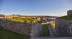
Charles Fort is one of the finest surviving examples of a 17th Century star-shaped fort, and much of the construction begun in 1678 remains. It is built on the site of an earlier stronghold known as Ringcurran Castle, which featured prominently during the Siege of Kinsale in 1601. The fort, which is named after Charles II, was designed by the Surveyor-general Sir William Robinson — architect of the Royal Hospital Kilmainham. The star fortification layout was specifically designed to resist attack by cannon.
The fort has two enormous bastions overlooking the estuary, and three facing inland. Within its walls were all the barracks and ancillary facilities to support the fort’s garrison.
The fort was relinquished by British forces following the Anglo-Irish Treaty, but it fell out of use after being burned by the retreating anti-Treaty forces during the Irish Civil War in 1922. The complex was named a National Monument of Ireland in 1971 and has been partly restored by Dúchas, the Irish heritage service.
A full detailed history can be seen at the exhibition centre on site.
James Fort
James Fort holds a commanding position directly across the harbour mouth from Charles Fort. Together, these forts guarded the narrow harbour entrance.
Before James fort was constructed, an earlier medieval fortification existed on the site. This fortification, named Castle Ny-Parke was occupied for a time by Spanish forces during the early part of the Siege of Kinsale. It was captured however from the Spanish by Sir Richard Smyth who led the attacking English forces of Charles Blount, Lord Mountjoy.
Construction of James Fort, which is named after James I of England and VI of Scotland, started in 1602 — immediately after the Siege of Kinsale. The new fort was constructed to designs by Paul Ive (to replace the older medieval structure) and was completed in 1607.
As with Charles Fort on the other side of the harbour, James Fort was occupied by Jacobite forces during the Williamite War in Ireland. It was captured however in 1690 by Williamite forces.
It has undergone much alteration in the intervening centuries.
The Luisitania
RMS Lusitania was a British ocean liner with the Cunard Line, which travelled between Liverpool, England and New York City, including a port of call at Queenstown, (now Cobh) Ireland on westbound crossings and Fishguard, Wales on eastbound crossings.
During the First World War, as Germany waged submarine warfare against Britain, the ship was identified and torpedoed by a German U-boat on 7 May 1915, 11 miles (18 km) off the Old Head of Kinsale.
Almost immediately, the crew scrambled to launch the lifeboats. While the Lusitania carried more than enough lifeboats for all on board, the conditions of the sinking made their usage extremely difficult, and in some cases impossible due to the ship’s severe list. In all, only six out of 48 lifeboats were launched successfully, with several more overturning, splintering to pieces and breaking apart. Eighteen minutes after the torpedo struck, the bow struck the seabed while the stern was still above the surface, and in a manner similar to the sinking of the Titanic three years earlier, the stern rose into the air and slid beneath the waves.
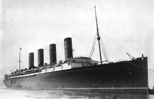
Of the 1,959 passengers and crew aboard the Lusitania at the time of the sinking, 1,195 lost their lives that afternoon in the waters of the Irish channel. Just as had been seen with the Titanic, most of the casualties were from drowning or from hypothermia. In the hours after the sinking, acts of heroism amongst both the survivors of the sinking and the Irish rescuers who had heard word of the Lusitania’s distress signals brought the survivor count to 764. By the following morning, news of the disaster had spread around the world. While most of those lost in the sinking were either British or Canadians, the loss of 123 Americans in the disaster outraged the United States, and would play a crucial role in the United States’ entry into the First World War against Germany two years later.
The wreck of the Lusitania lies on its starboard side at an approximately 30 degree angle in roughly 300 feet of water, 11 miles south of the lighthouse at Kinsale. The wreck is badly collapsed onto her starboard side, due to the force with which she struck the bottom coupled with the forces of winter tides and corrosion in the decades since the sinking. The keel has an ‘unusual curvature’, which may be related to a lack of strength from the loss of its superstructure. The beam is reduced with the funnels missing presumably to deterioration. The bow is the most prominent portion of the wreck with the stern damaged by depth charges, having been used for target practice by the Irish Navy in the Second World War, as well as the removal of three of the four propellers by Oceaneering International in 1982.
Ringfinnan Garden of Remembrance
Ringfinnan Garden of Remembrance is dedicated to the memory of Fr. Michael Judge, Chaplain in the New York Fire Department and to the 343 brave fire fighters, who so courageously lost their lives in New York on September 11th 2001.
The Kinsale Garden of Remembrance was initiated by Kathleen Murphy, a nurse in New York City. She was born in Ringfinnan, Kinsale and her family continue to reside here. The first tree planting ceremony took place in November 2001.
The dedication ceremony was attended by Irish relatives of the deceased New York fire fighters. Many of the fire fighters were of Irish descent and the garden has been visited on a regular basis by American visitors to Ireland. Attached to each tree is the name of each individual fireman.
To get to Ringfinnan from Kinsale, go past the Trident Hotel along the road road running parallel with the Bandon River in the direction of Cannon Duggan Bridge. At the bridge, turn left and go over the bridge, then take a right turn. After 200 yards, turn right up the hill to Ringfinnan following the signpost.
St. Multose Church
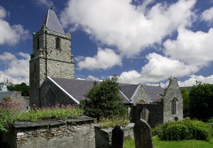
Built in 1190, this church has remained in continuous use to the present day. Some interesting features include an inscription in Norman French, the Easter sepulchre, the Baptismal font, the carved memorials, and the reredos from the Galway chapel as well as the wooden Coat of Arms.
The Southwell Memorial in Carrera marble, is the work of Arnold Quellin of London. It was in this church that Prince Rupert proclaimed Charles II as King, after hearing the news that Cromwell had had King Charles I executed in London. Prince Rupert’s fleet was at anchor in Kinsale harbour at the time.
The Courthouse & Regional Museum
This interesting building was built about 1600, with additions in 1706 that included the frontage with the loggia on the ground floor. Offices and a jury room were provided on the first floor, and part of the original building was converted into an interesting panelled courtroom. In this building the Kinsale Town Corporation and Sovereign conducted their affairs. The courthouse was also used for ceremonial occasions in the 18th century. On Monday 10th 1915, the Courthouse was used for the inquest into the loss of the liner Lusitania. Captain Turner gave evidence before a jury of twelve shopkeepers and fishermen. The Regional Museum is now housed in the Courthouse.
Desmond Castle & the International Museum of Wine
Built as an urban tower house by the Earl of Desmond c. 1500, Desmond Castle has served as Customs House, Prison, Ordnance store and a Workhouse. The Museum details the history of the Wine Geese; the intriguing story of Ireland’s wine links with Europe and the wider world. This is an essential half-hour all-weather activity.
Desmond Castle was built in about 1500 by Maurice Bacach Fitzgerald, Earl of Desmond. It has had many uses. In 1600 and 1601 it was used as an arsenal by Don Juan Aguilla during the Spanish occupation of the town which lasted for 100 days prior to the Battle of Kinsale in 1601.
Kinsale was a designated Wine Port, and a supplier of ships for the Vintage Fleet as far back as 1412. In that year, the Vintage Fleet of some 160 vessels plying to and fro from Bordeaux included five Irish vessels, three of which were from Kinsale, and two from Dublin. More information on the wine trade can be found at www.winegeese.ie. Desmond Castle was also used as a customs house.
In the 17th century the castle became popularly known as the “French prison” and was used for prisoners of war, most of whom were captured at sea. The majority of the prisoners were French, but many nationalities were ransomed or exchanged for their British counterparts. Some prisoners were housed in nearby huts, and the conditions were grim, with overcrowding, lack of food, starvation and disease. A disastrous fire in 1747 killed 54 prisoners.
During the American War of Independence, the crews of many American vessels were held prisoner in Kinsale in poor conditions. Help came from Rev. William Hazlett, a Presbyterian Minister in nearby Bandon, and from Reuben Harvey, a Quaker merchant in Cork. Through their influence conditions were improved. In 1783, George Washington thanked Harvey for “his exertions in relieving the distresses of such of our fellow citizens as were prisoners in Ireland”.
The ‘Wild Geese’ was the name given to the thousands of families who migrated from Ireland from the 17th to the 19th centuries due to religious persecution, violation of treaties and prohibitive commercial legislation. Some of them entered the wine trade and are often referred to as the “Irish Wine Geese”. Their descendants can be found in the four corners of the world. Desmond Castle was restored by the Office of Public Works and now houses the International Museum of Wine, which opened in 1997. The exhibition uses a variety of media to recall the castle’s eventful history and the amazing story of the Irish links to the wine trade, which stretch back to Irish mythology and continue into the present day.
Opening Hours: 21st April – 21st September: Daily 10.00 – 18.00.
Things to do
However relaxed or active you wish to be on your holiday, Kinsale offers you a world of choice but allows you to take things at your own pace. Kinsale is a yachting and deep-sea angling centre and in recent years a world class golf destination and marine adventure activities hub.
Walking
Kinsale has five heritage walks taking in the major historical points around the town. See Kinsale Heritage Walks under the Walking section for map and details.
For a guided historical tour of Kinsale contact Dermot Ryan at 086 8267656 or www.kinsaleheritage.com
Garrettstown Wood is located on the edge of Ballinspittle Village, close to Kinsale. There are two waymarked woodland trails to enjoy within this woodland. See Garrettstown Wood Trails under the Walking Routes section.
Golf
There are three spectacular golf courses around Kinsale. Kinsale Golf Club offers two courses to savour, the rolling fairways of Farrangalway and the slopes running into the water at Ringenane. The Old Head of Kinsale Golf Club has a spectacular 18-hole links course with the lighthouse as a backdrop.
Arts & Crafts
Kinsale has a strong history in the arts and crafts guilds. Pottery, silver, gold, candles, glassware are all manufactured in the town, while the other artistic fields of sculpture, painting in all mediums, ceramics and photography are well represented by inspired local artists. There are numerous galleries around the town where you can view or purchase these works.
Each July Kinsale hosts the biggest Arts Festival in West Cork — one of the highlights on the Cork Summer Calendar.
Fishing and Angling
Along the coast if Kinsale are many fine spots for fishing with the possibility of sighting dolphins, whales and seals! The deep harbour allows access at all stages of the tide, and the fishing grounds are only a short steaming time from port. The waters off the West Cork coast are crystal clear and ideal for angling. The climate is temperate and the marine life abundant…an angler’s utopia!
For a number of years Kinsale has been an important deep sea angling centre, and blue shark are a speciality of the town. The wreck of the Lusitania lying 11.5 miles from the Old Head of Kinsale is an excellent and very popular angling mark.
Game angling for salmon and trout is available on the Bandon River. There are some good shore angling marks from the rocks on the Old Head of Kinsale and the new bridge in Kinsale is a favourite spot at certain stages of the tide.
Swimming
This part of West Cork is very well known for its beaches with both Garrylucas and Garrettstown achieving Blue Flags for excellence of water quality. Great for swimming and surfing in summer or just walking whilst listening to the birds and waves on clear winter days.
Garrylucas is a sandy beach with sand dunes in parts. Located beside the R604 road and adjacent to Kilcolman Marsh and The Old Head of Kinsale. The beach is lifeguarded during the bathing season (lifeguard times and days are posted on the information noticeboard at the beach). Access to the beach is by ramps and steps.
Garretstown is a sandy beach located on the R604 road and adjacent to Kilcolman Marsh and The Old Head of Kinsale and within a short distance of Ballinspittle village by car. Public parking and toilets are provided adjacent to the beach and lifeguards are on duty on weekends during the bathing season (lifeguard times are displayed on the information noticeboard at the beach). Access to the beach by ramps and steps. Wheelchair access is provided.
